Northern Village of Buffalo Narrows
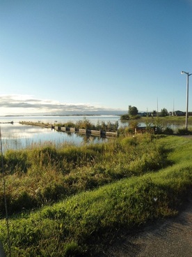
The Northern Village of Buffalo Narrows is located in North-west Saskatchewan at the connection of Peter Pond and the Churchill Lakes. The community lies along highway 155 that extends between La Loche in the north and Beauval in the south. With a population of 1014 (2021 Census), Buffalo Narrows is one of the largest communities in north-west Saskatchewan.
The community has been in existence for centuries due to its prime location at the Narrows between Peter Pond and Churchill Lakes. There was much fur trading through this area due to the transportation route between the Methy Portage up near La Loche, SK and the Île-à-la-Crosse peninsula further south. ![]()
|
Planning Documents
*All plans and bylaws available for download on this site may not include amendments and must not be used for legal purposes.
Contact the municipality for updated bylaws and maps.*

Frequently Asked Questions about the Village's Official Community Plan and Zoning Bylaw:
Do you know what an Official Community Plan and Zoning Bylaw are? Do you think zoning bylaws restrict lands sales? Are you unsure about what role government plays in developing an OCP and zoning bylaw? Click here for answers to these questions and more.
Historical Studies
Future Growth Study (2006): The expected growth of Buffalo Narrows due to the resource extraction expansion in Northern Saskatchewan prompted the community to develop a plan for future growth. This document goes into detail about projected growth and provides concept plans on how the development could occur.
|
![]()
![]()
|
Schematic Truck Routes (2006): As the Northern Village of Buffalo Narrows grows in the future, accommodations will have to be made for increased traffic flow through the community. Due to the municipalities location at the Narrows between Peter Pond and Churchill Lakes all traffic must go through the community. This raises concerns not only for increased traffic, but also the type of traffic that passes through the municipality that may be more dangerous. This map shows where future transportation routes can be diverted to allow for community growth while maintaining safety for local residents.
|
![]()
|
Municipal Constraints (2006): There are certain areas within the municipal boundary of Buffalo Narrows that are unsuitable for future development because of existing infrastructure, areas set aside as buffers between land-uses, flood levels, or natural impediments, such as muskeg or rivers.
|
![]()
![]()
|
Infrastructure Expansion (2006): In anticipation of growth for the Northern Village of Buffalo Narrows, the expansion of existing waterworks infrastructure to provide services to future residents must be considered. This map identifies existing waterworks infrastructure, and then future expansion concepts.
Lagoon Expansion Site Plan (2006): As Buffalo Narrows grows, existing infrastructure, such as the sewer lagoon, will need to be replaced with a larger facility to accommodate more residents. This map identifies the most suitable location and size needed for the projected growth. WTP Expansion Site Plan (2006): Similarly, as population and services expand within the municipality, the Water Treatment Plant (WTP) will need to be upgraded and expanded to accommodate this. This map identifies the most suitable location and size needed for the expected growth. |
![]()
![]()
![]()
|
Wildfire Risk Assessment (2005): The Saskatchewan Ministry of Environment actively attempts to educate residents about the threat of fire within municipalities. They conducted an assessment of each municipality to determine the likelihood of wildfires, and implement FireSmart principles to help reduce the chances of wildfires starting.
|
![]()
|
Flood Hazard Level (2012): The Saskatchewan Watershed Authority, now referred to as the Water Security Agency, released in 2012 an updated elevation levels for Buffalo Narrows that shows the areas within the municipality that have an increased likelihood of flooding within the municipality. This map is important to understand where municipal constraints exist within the municipality.
|
![]()
|
Community Highlights (2012): The Saskatchewan Ministry of First Nations and Metis Relations, with help of the Ministry of the Economy conducted a snapshot in 2012 of the key components of the community, including: local government, demographics, economic environment, training and education, infrastructure, housing, emergency services, recreational opportunities, and the community's distance from larger centres.
|
![]()
|