PLANNING FOR GROWTH NORTH
  • Home
  • Northern Municipal Services
    • About Northern Municipal Services
    • About the District (municipality)
    • About the Northern Saskatchewan Administration District
    • Northern Municipal Trust Account Programs >
      • About the NMTA & Board
      • Circuit Rider Program (ATAP)
      • Northern Capital Grants Program
      • Northern Municipal Revenue Sharing
      • Northern Water and Sewer Program
      • Planning for Growth North
      • Wildfire Mitigation Project
  • Northern Municipalities
    • Towns >
      • La Ronge
      • Creighton
    • Northern Villages >
      • Air Ronge
      • Beauval
      • Buffalo Narrows
      • Cumberland House
      • Denare Beach
      • Green Lake
      • Ile-a-la Crosse
      • La Loche
      • Pelican Narrows
      • Pinehouse
      • Sandy Bay
    • Northern Hamlets >
      • Black Point
      • Cole Bay
      • Dore Lake
      • Jans Bay
      • Michel Village
      • Patuanak
      • St. George's Hill
      • Stony Rapids
      • Timber Bay
      • Turnor Lake
      • Weyakwin
    • 2021 Population
  • District Communities & Areas
    • Northern Settlements >
      • About
      • Bear Creek
      • Brabant
      • Camsell Portage
      • Descharme Lake
      • Garson Lake
      • Missinipe
      • Sled Lake
      • Southend
      • Stanley Mission
      • Uranium City
      • Wollaston Lake
    • Resort Subdivisions >
      • About
      • East Trout Lake
      • Jan Lake
      • Keeley Lake
      • Lac La Plonge
      • Little Amyot Lake
      • Little Bear Lake
      • Michel Point
      • Napatak
      • Ramsey Bay
      • Sturgeon Weir
      • Tower Beach
      • Tyrrell Lake
      • Waden Bay
      • Whelan Bay
    • Northern Subdivisions >
      • Deschambault Lake
      • Eagle Point
      • English Bay
      • Kinoosao
      • Lamp Lake
      • Nemeiben Lake
      • Potato Lake
      • Sturgeon Landing
    • Lac La Ronge Planning Area >
      • About
      • Development in the Planning Area
      • Planning Bylaws & Maps
      • Advisory Northern Planning Commission
    • 2021 Population
  • District Services
    • District Services
    • Accounts Payable and Accounts Receivable
    • Assessment Notice FAQ
    • Employment Opportunities
    • Development Permits & Subdivision
    • Land Sales and Leases
    • Public Notices & Fire Bans
    • Tax Certificate Requests
  • NSAA
    • NSAA Conferences >
      • May 2024
      • September 2024
      • April 2025
  • Toolkits & Resources
    • Legislation
    • Bylaw Guides
    • Governance and Administration
    • Assessment & Taxation
    • First Nations & Métis Engagement
    • Community Health, Safety and Wellbeing
    • Land Use Planning
    • Emergency Preparedness and Community Safety
    • Maps & Databases
  • Contact Us

Lac La Ronge Planning Area

Planning Bylaws & Maps
Building Info
Advisory Northern Planning Commission
Meeting Information
​The Lac La Ronge Planning Area and the Advisory Northern Planning Commission (ANPC) were established by Minister's Order on January 31, 2006. The role of the ANPC is to advise and assist the Minister of Government Relations with respect to community planning and development matters in the Planning Area (The Planning and Development Act, 2007, ss. 111(4)). The ANPC is not an elected council or decision-making body.

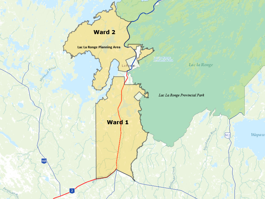
Communities in the Planning Area include (see map below):
  • Napatak (Ward 1)
  • Rabbit Creek (Ward 1)
  • Potato Lake (Ward 1)
  • Lamp Lake (Ward 2)
  • Eagle Point (Ward 2)
  • Nemeiben​ (Ward 2)
* The area within the Town of La Ronge, the Village of Air Ronge and the Lac La Ronge Indian Band boundaries do not form part of the Lac La Ronge Planning Area but representatives from each of those communities are members of the ANPC.

The purpose and objectives of the Planning Area are:

a) To manage the use of land of the Lac La Ronge Planning Area in an integrated and environmentally sound manner to ensure ecological, economic and social benefits for present and future generations.
b) To develop clear land use guidelines that allow for controlled, orderly development.
c) To promote the integration of planning processes between the existing jurisdictions in and adjacent to the planning area.
d) To work toward resolving conflicts among users.
e) To provide a mechanism for local public involvement in land use management.

Background:

The authority for land use and development in the Lac La Ronge Planning Area lies with its Official Community Plan (OCP) Bylaw and Zoning Bylaw (under authority of The Planning and Development Act, 2007). The Advisory Northern Planning Commission (ANPC), OCP and Zoning Bylaw stem from the La Ronge Integrated Land Use Management Plan (ILUMP) developed by the Ministry of Environment in 2003 and endorsed by Cabinet. The purpose of the ILUMP was not to focus on the detailed planning required to address land use needs but rather to provide general direction for land and resource management in the “La Ronge Planning Area” over the plan's 5 year lifespan. Under ILUMP, the Ministry of Government Relations was responsible for implementing the policies of the ILUMP through a more detailed land use policy and development regulations. The LLRPA and the ANPC were established by Minster’s Order in 2006 for this purpose and the LLRPA’s OCP and Zoning Bylaw were adopted in 2011. 

Picture

Back to Top

 Northern Municipal Services:
​1-800-663-1555
​[email protected]

  • Home
  • Northern Municipal Services
    • About Northern Municipal Services
    • About the District (municipality)
    • About the Northern Saskatchewan Administration District
    • Northern Municipal Trust Account Programs >
      • About the NMTA & Board
      • Circuit Rider Program (ATAP)
      • Northern Capital Grants Program
      • Northern Municipal Revenue Sharing
      • Northern Water and Sewer Program
      • Planning for Growth North
      • Wildfire Mitigation Project
  • Northern Municipalities
    • Towns >
      • La Ronge
      • Creighton
    • Northern Villages >
      • Air Ronge
      • Beauval
      • Buffalo Narrows
      • Cumberland House
      • Denare Beach
      • Green Lake
      • Ile-a-la Crosse
      • La Loche
      • Pelican Narrows
      • Pinehouse
      • Sandy Bay
    • Northern Hamlets >
      • Black Point
      • Cole Bay
      • Dore Lake
      • Jans Bay
      • Michel Village
      • Patuanak
      • St. George's Hill
      • Stony Rapids
      • Timber Bay
      • Turnor Lake
      • Weyakwin
    • 2021 Population
  • District Communities & Areas
    • Northern Settlements >
      • About
      • Bear Creek
      • Brabant
      • Camsell Portage
      • Descharme Lake
      • Garson Lake
      • Missinipe
      • Sled Lake
      • Southend
      • Stanley Mission
      • Uranium City
      • Wollaston Lake
    • Resort Subdivisions >
      • About
      • East Trout Lake
      • Jan Lake
      • Keeley Lake
      • Lac La Plonge
      • Little Amyot Lake
      • Little Bear Lake
      • Michel Point
      • Napatak
      • Ramsey Bay
      • Sturgeon Weir
      • Tower Beach
      • Tyrrell Lake
      • Waden Bay
      • Whelan Bay
    • Northern Subdivisions >
      • Deschambault Lake
      • Eagle Point
      • English Bay
      • Kinoosao
      • Lamp Lake
      • Nemeiben Lake
      • Potato Lake
      • Sturgeon Landing
    • Lac La Ronge Planning Area >
      • About
      • Development in the Planning Area
      • Planning Bylaws & Maps
      • Advisory Northern Planning Commission
    • 2021 Population
  • District Services
    • District Services
    • Accounts Payable and Accounts Receivable
    • Assessment Notice FAQ
    • Employment Opportunities
    • Development Permits & Subdivision
    • Land Sales and Leases
    • Public Notices & Fire Bans
    • Tax Certificate Requests
  • NSAA
    • NSAA Conferences >
      • May 2024
      • September 2024
      • April 2025
  • Toolkits & Resources
    • Legislation
    • Bylaw Guides
    • Governance and Administration
    • Assessment & Taxation
    • First Nations & Métis Engagement
    • Community Health, Safety and Wellbeing
    • Land Use Planning
    • Emergency Preparedness and Community Safety
    • Maps & Databases
  • Contact Us