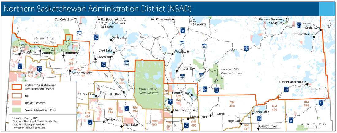
The Northern Saskatchewan Administration District (NSAD)
The Northern Saskatchewan Administration District (NSAD) is northern Saskatchewan as an entire physical area and includes: incorporated municipalities, designated park land, First Nation reserves, and all other unorganized areas. The NSAD is legally described in section 74 of The Northern Municipalities Regulations. Follow this link to see how NMS supports communities in the NSAD and administers the District: Northern Municipal Services Video
Municipalities in the NSAD:
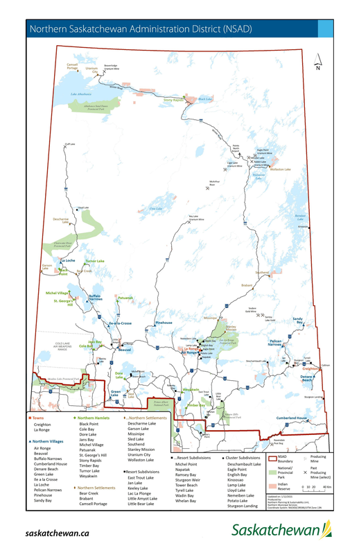
There are 25 incorporated municipalities in the NSAD:
- 2 Towns
- 11 Northern Villages
- 11 Northern Hamlets
- The District - a single municipality that covers the unorganized area of northern Saskatchewan. The District can be thought of like a northern rural municipality (RM). Unorganized means all areas outside of incorporated municipalities and designated Park land.
Other Jurisdictions in the NSAD:
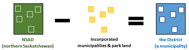
The District
The District is a single incorporated municipality in the NSAD. The District can be thought of like a ‘northern RM’ where the District includes all of the unorganized area in the NSAD and excludes incorporated municipalities (towns, northern villages and northern hamlets) and designated Park land in the NSAD.
Most of the land in the District is Crown land. Northern Municipal Services (NMS) holds the unique responsibility to act as the local government authority for the District. The District is governed by the Minister of Government Relations who acts as mayor and council for the District as a municipality. Follow this link to see how NMS supports communities in the NSAD and administers the District: Northern Municipal Services Video
The unorganized communities of the District include:
The unorganized communities of the District include:
- 11 northern settlements
- 14 resort subdivisions
- 9 northern subdivisions, and
- upwards of 8,000 leases
Did You Know?
- The NSAD designation dates back to The Northern Administration Act, 1948, which provided for northern administration and development.
- The NSAD covers approximately 321,163 square kilometres or 49% of Saskatchewan's area.
- NSAD 2021 Census population: 35,986 people (on- and off-reserve), or approximately 3% of the province's population.
- Statistics Canada refers to the NSAD as "Division No. 18". Division No. 18 has the same boundary as the NSAD.
- Statistics Canada refers to the District (a municipality) as "Division No. 18, Unorganized".
- The Northern Municipal Trust Account is the special account which provides the funds to administer the District. The Northern Municipal Trust Account Management Board is appointed to make recommendations to the Minister of Government Relations.
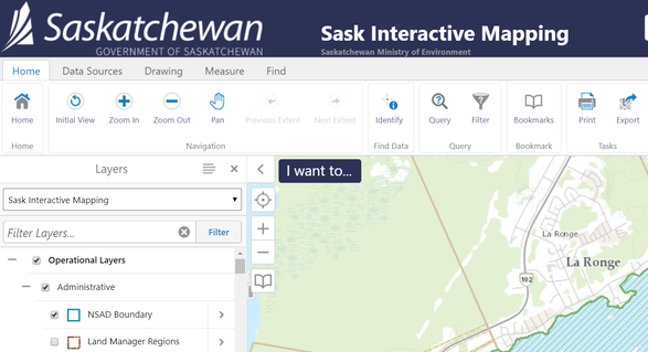
NSAD Boundary Maps
(Check off the "Administrative>NSAD Boundary layer" under the Layers tab. Best viewed on a desktop.)