PLANNING FOR GROWTH NORTH
  • Home
  • Northern Municipal Services
    • About Northern Municipal Services
    • District Administration (municipality) >
      • About the District (municipality)
      • Assessment Notice FAQ
      • Accounts Payable and Accounts Receivable
      • Employment Opportunities
    • Public Notices in the District
    • Northern Municipal Trust Account Programs >
      • About the NMTA & Board
      • Northern Capital Grants Program
      • Northern Water and Sewer Program
      • Wildfire Mitigation Project
    • Northern Planning and Sustainability Unit >
      • About NPS Unit
      • Planning for Growth North
  • Northern Communities & Areas
    • The Northern Saskatchewan Administration District (NSAD)
    • Towns >
      • La Ronge
      • Creighton
    • Northern Villages >
      • Air Ronge
      • Beauval
      • Buffalo Narrows
      • Cumberland House
      • Denare Beach
      • Green Lake
      • Ile-a-la Crosse
      • La Loche
      • Pelican Narrows
      • Pinehouse
      • Sandy Bay
    • Northern Hamlets >
      • Black Point
      • Cole Bay
      • Dore Lake
      • Jans Bay
      • Michel Village
      • Patuanak
      • St. George's Hill
      • Stony Rapids
      • Timber Bay
      • Turnor Lake
      • Weyakwin
    • District >
      • About
      • Northern Settlements >
        • About
        • Bear Creek
        • Brabant
        • Camsell Portage
        • Descharme Lake
        • Garson Lake
        • Missinipe
        • Sled Lake
        • Southend
        • Stanley Mission
        • Uranium City
        • Wollaston Lake
      • Resort Subdivisions >
        • About
        • East Trout Lake
        • Jan Lake
        • Keeley Lake
        • Lac La Plonge
        • Little Amyot Lake
        • Little Bear Lake
        • Michel Point
        • Napatak
        • Ramsey Bay
        • Sturgeon Weir
        • Tower Beach
        • Tyrrell Lake
        • Waden Bay
        • Whelan Bay
      • Cluster Subdivisions >
        • Deschambault Lake Subdivision
        • Eagle Point Subdivision
        • English Bay Subdivision
        • Kinoosao Subdivision
        • Lamp Lake Subdivision
        • Lloyd Lake Subdivision
        • Nemeiben Lake Subdivision
        • Potato Lake Subdivision
        • Sturgeon Landing Subdivision
      • Development and Land Sales in the District
      • Public Notices in the District
    • Lac La Ronge Planning Area >
      • About
      • Development in the Planning Area
      • Planning Bylaws & Maps
      • Advisory Northern Planning Commission
  • Toolkits & Resources
    • Legislation
    • Bylaw Guides
    • Population
    • Governance and Administration
    • Waterworks Reporting
    • Assessment & Taxation
    • First Nations & Métis Engagement
    • Community Health, Safety and Wellbeing
    • Land Use Planning
    • Emergency Preparedness and Community Safety
    • Maps & Databases
  • Contact Us

Maps & Data

Explore Sask GeoHub
Picture
Sask GeoHub is the Government of Saskatchewan's central online space to share, explore and download spatial data and maps from its ministries. New data is added frequently, check back often.

Explore SaskInteractive
Picture
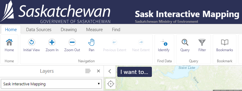
SaskInteractive is an online mapping application from the Government of Saskatchewan where you can view data on a wide variety themes such as: Aboriginal lands, active wildfires, environmental assessment, landfills, parcel fabric, air quality, ​school locations and more.

Explore COVID-19 Dashboard
Picture
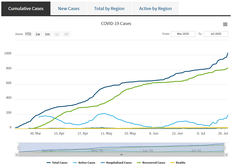
The COVID-19 Dashboard is the authoritative source for COVID-19 data and trends from the Government of Saskatchewan covering a wide array of indicators such as hospitalizations, recoveries, testing and active cases by region.  ​

Explore Community Census Profiles
Picture
The 2021 Census Community Profile provides a quick view of provincial and community level data from the Census such as population, housing, employment, identity and language. ​

Explore SAMAView
Picture
​​SAMAView, a service of SAMA, provides public access to search, view and compare individual property assessments in all SAMA’s client jurisdictions. Access is free of charge for personal and non-commercial users.
​

Explore ISC
Picture
ISC is the provincial land titles administrator and corporate registry administrator. Contact ISC or explore their website for information on: property ownership, property interests, survey plans and more. 

Explore First Nations Profiles
Picture
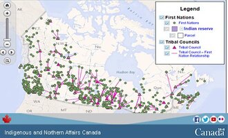
The First Nation Profiles describes individual First Nation communities across Canada and is maintained by Indigenous Services Canada. Profiles include: governance, federal funding, geography, registered population statistics and various Census statistics.

Back to Top

 Northern Municipal Services:
​1-800-663-1555
​NMS@gov.sk.ca

  • Home
  • Northern Municipal Services
    • About Northern Municipal Services
    • District Administration (municipality) >
      • About the District (municipality)
      • Assessment Notice FAQ
      • Accounts Payable and Accounts Receivable
      • Employment Opportunities
    • Public Notices in the District
    • Northern Municipal Trust Account Programs >
      • About the NMTA & Board
      • Northern Capital Grants Program
      • Northern Water and Sewer Program
      • Wildfire Mitigation Project
    • Northern Planning and Sustainability Unit >
      • About NPS Unit
      • Planning for Growth North
  • Northern Communities & Areas
    • The Northern Saskatchewan Administration District (NSAD)
    • Towns >
      • La Ronge
      • Creighton
    • Northern Villages >
      • Air Ronge
      • Beauval
      • Buffalo Narrows
      • Cumberland House
      • Denare Beach
      • Green Lake
      • Ile-a-la Crosse
      • La Loche
      • Pelican Narrows
      • Pinehouse
      • Sandy Bay
    • Northern Hamlets >
      • Black Point
      • Cole Bay
      • Dore Lake
      • Jans Bay
      • Michel Village
      • Patuanak
      • St. George's Hill
      • Stony Rapids
      • Timber Bay
      • Turnor Lake
      • Weyakwin
    • District >
      • About
      • Northern Settlements >
        • About
        • Bear Creek
        • Brabant
        • Camsell Portage
        • Descharme Lake
        • Garson Lake
        • Missinipe
        • Sled Lake
        • Southend
        • Stanley Mission
        • Uranium City
        • Wollaston Lake
      • Resort Subdivisions >
        • About
        • East Trout Lake
        • Jan Lake
        • Keeley Lake
        • Lac La Plonge
        • Little Amyot Lake
        • Little Bear Lake
        • Michel Point
        • Napatak
        • Ramsey Bay
        • Sturgeon Weir
        • Tower Beach
        • Tyrrell Lake
        • Waden Bay
        • Whelan Bay
      • Cluster Subdivisions >
        • Deschambault Lake Subdivision
        • Eagle Point Subdivision
        • English Bay Subdivision
        • Kinoosao Subdivision
        • Lamp Lake Subdivision
        • Lloyd Lake Subdivision
        • Nemeiben Lake Subdivision
        • Potato Lake Subdivision
        • Sturgeon Landing Subdivision
      • Development and Land Sales in the District
      • Public Notices in the District
    • Lac La Ronge Planning Area >
      • About
      • Development in the Planning Area
      • Planning Bylaws & Maps
      • Advisory Northern Planning Commission
  • Toolkits & Resources
    • Legislation
    • Bylaw Guides
    • Population
    • Governance and Administration
    • Waterworks Reporting
    • Assessment & Taxation
    • First Nations & Métis Engagement
    • Community Health, Safety and Wellbeing
    • Land Use Planning
    • Emergency Preparedness and Community Safety
    • Maps & Databases
  • Contact Us