Northern Settlement of Stanley Mission
Public Notices
- 2024 Operating Budget
- 2023 Pay List
- Annual Notice to Consumers - Drinking Water Quality and Compliance (June 18, 2024)
- Annual Waterworks Information (August 18, 2022)
|
The Northern Settlement of Stanley Mission is located 79 km northeast of La Ronge via Highways 102 and 915. The settlement is adjacent to Lac La Ronge Indian Band's Stanley Reserve 157 and Lac La Ronge Provincial Park. The community is situated along the southern shores of Mountain Lake and Harvesting Bay, part of the Churchill River system.
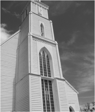
Stanley Mission is one of the oldest settlements in northern Saskatchewan. Across the lake, Holy Trinity Church is a national heritage site. District facilities include a community hall with kitchen, outdoor rink, and municipal garage. The water distribution and sewage collection systems are operated by LLRIB along with other services provided to the settlement through a municipal services agreement. The current population is 104 people (2021 Census)* (officially revised to 96). |
|
The Role of the Local Advisory Committee (LAC)
Click here to learn about the important roles that District municipal administration and the LAC play in responsibly managing the affairs and the wellbeing of Stanley Mission. The current LAC members are Annie McLeod (chair) and Frank McLeod.