PLANNING FOR GROWTH NORTH
  • Home
  • COVID-19
  • Northern Municipal Services
    • Northern Municipal Services
    • Administration of the District (municipality) >
      • The District (municipality)
      • Public Notices in the District
      • Assessment Notice FAQ
      • District: Accounts Payable and Accounts Receivable
    • Northern Municipal Trust Account (NMTA) >
      • NMTA & Board
      • Northern Capital Grants Program
      • Northern Water and Sewer Program
      • Wildfire Mitigation Project
    • Northern Planning and Sustainability (NPS) >
      • NPS Unit
      • Planning for Growth North
  • Northern Communities & Areas
    • The Northern Saskatchewan Administration District (NSAD)
    • Towns >
      • La Ronge
      • Creighton
    • Northern Villages >
      • Air Ronge
      • Beauval
      • Buffalo Narrows
      • Cumberland House
      • Denare Beach
      • Green Lake
      • Ile-a-la Crosse
      • La Loche
      • Pelican Narrows
      • Pinehouse
      • Sandy Bay
    • Northern Hamlets >
      • Black Point
      • Cole Bay
      • Dore Lake
      • Jans Bay
      • Michel Village
      • Patuanak
      • St. George's Hill
      • Stony Rapids
      • Timber Bay
      • Turnor Lake
      • Weyakwin
    • District >
      • Settlements >
        • Bear Creek
        • Brabant
        • Camsell Portage
        • Descharme Lake
        • Garson Lake
        • Missinipe
        • Sled Lake
        • Southend
        • Stanley Mission
        • Uranium City
        • Wollaston Lake
      • Resort Subdivisions >
        • East Trout Lake
        • Jan Lake
        • Keeley Lake
        • Lac La Plonge
        • Little Amyot Lake
        • Little Bear Lake
        • Michel Point
        • Napatak
        • Ramsey Bay
        • Sturgeon Weir
        • Tower Beach
        • Tyrell Lake
        • Wadin Bay
        • Whelan Bay
      • Cluster Subdivisions >
        • Deschambault Lake Subdivision
        • Eagle Point Subdivision
        • English Bay Subdivision
        • Kinoosao Subdivision
        • Lamp Lake Subdivision
        • Lloyd Lake Subdivision
        • Nemeiben Lake Subdivision
        • Potato Lake Subdivision
        • Sturgeon Landing Subdivision
      • Development in the District
    • Lac La Ronge Planning Area >
      • Advisory Northern Planning Commission
      • Development in the Planning Area
      • Planning Bylaws & Maps
  • Toolkits & Resources
    • Legislation
    • Bylaw Guides
    • Emergency Preparedness and Community Safety
    • Governance and Administration
    • Assessment & Taxation
    • First Nations & Métis Engagement
    • Social Development and Healthy Communities
    • Land Use Planning
    • Maps & Databases
  • Contact Us

Northern Settlement of Uranium City

Annual Notice to Consumers - Drinking Water Quality and Compliance for the Northern Settlement of Uranium City

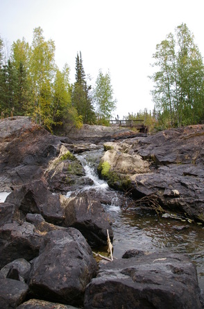
The Northern Settlement of Uranium City is one of Saskatchewan's most northern communities being located on the northern shore of Lake Athabasca.  

Previously, this community had a population of approximately 5,000 people when the Eldorado Mining and Refining corporation, owned by the Canadian government, was open and in operation.  Unfortunately, due to small uranium demand and federal cutbacks, the crown corporation was closed and the majority of residents, who worked for the company, were relocated south.  Within a few weeks the population dropped down to about 300 people.  This was further reduced in 2003 when the local hospital was relocated to Stony Rapids, which has now become the regional hub for the area. The population is currently 75 people.  

 
Uranium City Basemap
File Size: 339 kb
File Type: pdf
Download File

Picture

Planning Documents

*All plans and bylaws available for download on this site may not include amendments and should not be used for legal purposes*

Community Highlights (2012): The Saskatchewan Ministry of First Nations and Metis Relations, with help of the Ministry of the Economy conducted a snapshot in 2012 of the key components of the community, including: local government, demographics, economic environment, training and education, infrastructure, housing, emergency services, recreational opportunities, and the community's distance from larger centres.  
   
Community Highlights - 2012
File Size: 208 kb
File Type: pdf
Download File


Wildfire Risk Assessment (2005): The Saskatchewan Ministry of Environment actively attempts to educate residents about the threat of fire within municipalities.  They conducted an assessment of each municipality to determine the likelihood of wildfires, and implement FireSmart principles to help reduce the chances of wildfires starting.  
   
WRA - Uranium City
File Size: 6182 kb
File Type: pdf
Download File


Back to Top
  • Home
  • COVID-19
  • Northern Municipal Services
    • Northern Municipal Services
    • Administration of the District (municipality) >
      • The District (municipality)
      • Public Notices in the District
      • Assessment Notice FAQ
      • District: Accounts Payable and Accounts Receivable
    • Northern Municipal Trust Account (NMTA) >
      • NMTA & Board
      • Northern Capital Grants Program
      • Northern Water and Sewer Program
      • Wildfire Mitigation Project
    • Northern Planning and Sustainability (NPS) >
      • NPS Unit
      • Planning for Growth North
  • Northern Communities & Areas
    • The Northern Saskatchewan Administration District (NSAD)
    • Towns >
      • La Ronge
      • Creighton
    • Northern Villages >
      • Air Ronge
      • Beauval
      • Buffalo Narrows
      • Cumberland House
      • Denare Beach
      • Green Lake
      • Ile-a-la Crosse
      • La Loche
      • Pelican Narrows
      • Pinehouse
      • Sandy Bay
    • Northern Hamlets >
      • Black Point
      • Cole Bay
      • Dore Lake
      • Jans Bay
      • Michel Village
      • Patuanak
      • St. George's Hill
      • Stony Rapids
      • Timber Bay
      • Turnor Lake
      • Weyakwin
    • District >
      • Settlements >
        • Bear Creek
        • Brabant
        • Camsell Portage
        • Descharme Lake
        • Garson Lake
        • Missinipe
        • Sled Lake
        • Southend
        • Stanley Mission
        • Uranium City
        • Wollaston Lake
      • Resort Subdivisions >
        • East Trout Lake
        • Jan Lake
        • Keeley Lake
        • Lac La Plonge
        • Little Amyot Lake
        • Little Bear Lake
        • Michel Point
        • Napatak
        • Ramsey Bay
        • Sturgeon Weir
        • Tower Beach
        • Tyrell Lake
        • Wadin Bay
        • Whelan Bay
      • Cluster Subdivisions >
        • Deschambault Lake Subdivision
        • Eagle Point Subdivision
        • English Bay Subdivision
        • Kinoosao Subdivision
        • Lamp Lake Subdivision
        • Lloyd Lake Subdivision
        • Nemeiben Lake Subdivision
        • Potato Lake Subdivision
        • Sturgeon Landing Subdivision
      • Development in the District
    • Lac La Ronge Planning Area >
      • Advisory Northern Planning Commission
      • Development in the Planning Area
      • Planning Bylaws & Maps
  • Toolkits & Resources
    • Legislation
    • Bylaw Guides
    • Emergency Preparedness and Community Safety
    • Governance and Administration
    • Assessment & Taxation
    • First Nations & Métis Engagement
    • Social Development and Healthy Communities
    • Land Use Planning
    • Maps & Databases
  • Contact Us