PLANNING FOR GROWTH NORTH
  • Home
  • Northern Municipal Services
    • About Northern Municipal Services
    • District Administration (municipality) >
      • About the District (municipality)
      • Public Notices in the District
      • Assessment Notice FAQ
      • Accounts Payable and Accounts Receivable
    • Northern Municipal Trust Account Programs >
      • About the NMTA & Board
      • Northern Capital Grants Program
      • Northern Water and Sewer Program
      • Wildfire Mitigation Project
    • Northern Planning and Sustainability Unit >
      • About NPS Unit
      • Planning for Growth North
  • Northern Communities & Areas
    • The Northern Saskatchewan Administration District (NSAD)
    • Towns >
      • La Ronge
      • Creighton
    • Northern Villages >
      • Air Ronge
      • Beauval
      • Buffalo Narrows
      • Cumberland House
      • Denare Beach
      • Green Lake
      • Ile-a-la Crosse
      • La Loche
      • Pelican Narrows
      • Pinehouse
      • Sandy Bay
    • Northern Hamlets >
      • Black Point
      • Cole Bay
      • Dore Lake
      • Jans Bay
      • Michel Village
      • Patuanak
      • St. George's Hill
      • Stony Rapids
      • Timber Bay
      • Turnor Lake
      • Weyakwin
    • District >
      • Settlements >
        • Bear Creek
        • Brabant
        • Camsell Portage
        • Descharme Lake
        • Garson Lake
        • Missinipe
        • Sled Lake
        • Southend
        • Stanley Mission
        • Uranium City
        • Wollaston Lake
      • Resort Subdivisions >
        • East Trout Lake
        • Jan Lake
        • Keeley Lake
        • Lac La Plonge
        • Little Amyot Lake
        • Little Bear Lake
        • Michel Point
        • Napatak
        • Ramsey Bay
        • Sturgeon Weir
        • Tower Beach
        • Tyrell Lake
        • Wadin Bay
        • Whelan Bay
      • Cluster Subdivisions >
        • Deschambault Lake Subdivision
        • Eagle Point Subdivision
        • English Bay Subdivision
        • Kinoosao Subdivision
        • Lamp Lake Subdivision
        • Lloyd Lake Subdivision
        • Nemeiben Lake Subdivision
        • Potato Lake Subdivision
        • Sturgeon Landing Subdivision
      • Development in the District
    • Lac La Ronge Planning Area >
      • Advisory Northern Planning Commission
      • Development in the Planning Area
      • Planning Bylaws & Maps
  • Toolkits & Resources
    • Legislation
    • Bylaw Guides
    • Population
    • Governance and Administration
    • Assessment & Taxation
    • First Nations & Métis Engagement
    • Social Development and Healthy Communities
    • Land Use Planning
    • Emergency Preparedness and Community Safety
    • Maps & Databases
  • Contact Us

Northern Settlement of Garson Lake


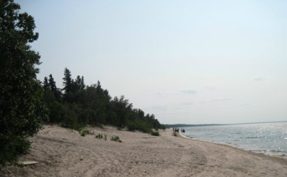
The Northern Settlement of Garson Lake is Northern Saskatchewan's most western municipality, almost being located on the Alberta - Saskatchewan border. The population is 10 people (2021 Census)


Garson Lake Basemap
File Size: 197 kb
File Type: pdf
Download File

Picture
Population Stats

The Role of the Local Advisory Committee (LAC)

Click here to learn about the important role that the LAC plays in responsibly managing the affairs and the wellbeing of Garson Lake. ​The current LAC chairperson for Garson Lake is Jocelyn LeMaigre and the two members are Dora Laprise and Danny Piche.

Planning Documents

*All plans and bylaws available for download on this site may not include amendments and must not be used for legal purposes.
​Contact the settlement for updated bylaws and maps.*

Community Highlights (2012): The Saskatchewan Ministry of First Nations and Metis Relations, with help of the Ministry of the Economy conducted a snapshot in 2012 of the key components of the community, including: local government, demographics, economic environment, training and education, infrastructure, housing, emergency services, recreational opportunities, and the community's distance from larger centres.  
   
Garson Lake Community Highlights
File Size: 180 kb
File Type: pdf
Download File


Wildfire Risk Assessment (2005): The Saskatchewan Ministry of Environment actively attempts to educate residents about the threat of fire within municipalities.  They conducted an assessment of each municipality to determine the likelihood of wildfires, and implement FireSmart principles to help reduce the chances of wildfires starting.  
  
WRA - Garson Lake
File Size: 5536 kb
File Type: pdf
Download File


Back to Top

 Northern Municipal Services:
​1-800-663-1555
​NMS@gov.sk.ca

  • Home
  • Northern Municipal Services
    • About Northern Municipal Services
    • District Administration (municipality) >
      • About the District (municipality)
      • Public Notices in the District
      • Assessment Notice FAQ
      • Accounts Payable and Accounts Receivable
    • Northern Municipal Trust Account Programs >
      • About the NMTA & Board
      • Northern Capital Grants Program
      • Northern Water and Sewer Program
      • Wildfire Mitigation Project
    • Northern Planning and Sustainability Unit >
      • About NPS Unit
      • Planning for Growth North
  • Northern Communities & Areas
    • The Northern Saskatchewan Administration District (NSAD)
    • Towns >
      • La Ronge
      • Creighton
    • Northern Villages >
      • Air Ronge
      • Beauval
      • Buffalo Narrows
      • Cumberland House
      • Denare Beach
      • Green Lake
      • Ile-a-la Crosse
      • La Loche
      • Pelican Narrows
      • Pinehouse
      • Sandy Bay
    • Northern Hamlets >
      • Black Point
      • Cole Bay
      • Dore Lake
      • Jans Bay
      • Michel Village
      • Patuanak
      • St. George's Hill
      • Stony Rapids
      • Timber Bay
      • Turnor Lake
      • Weyakwin
    • District >
      • Settlements >
        • Bear Creek
        • Brabant
        • Camsell Portage
        • Descharme Lake
        • Garson Lake
        • Missinipe
        • Sled Lake
        • Southend
        • Stanley Mission
        • Uranium City
        • Wollaston Lake
      • Resort Subdivisions >
        • East Trout Lake
        • Jan Lake
        • Keeley Lake
        • Lac La Plonge
        • Little Amyot Lake
        • Little Bear Lake
        • Michel Point
        • Napatak
        • Ramsey Bay
        • Sturgeon Weir
        • Tower Beach
        • Tyrell Lake
        • Wadin Bay
        • Whelan Bay
      • Cluster Subdivisions >
        • Deschambault Lake Subdivision
        • Eagle Point Subdivision
        • English Bay Subdivision
        • Kinoosao Subdivision
        • Lamp Lake Subdivision
        • Lloyd Lake Subdivision
        • Nemeiben Lake Subdivision
        • Potato Lake Subdivision
        • Sturgeon Landing Subdivision
      • Development in the District
    • Lac La Ronge Planning Area >
      • Advisory Northern Planning Commission
      • Development in the Planning Area
      • Planning Bylaws & Maps
  • Toolkits & Resources
    • Legislation
    • Bylaw Guides
    • Population
    • Governance and Administration
    • Assessment & Taxation
    • First Nations & Métis Engagement
    • Social Development and Healthy Communities
    • Land Use Planning
    • Emergency Preparedness and Community Safety
    • Maps & Databases
  • Contact Us