PLANNING FOR GROWTH NORTH
  • Home
  • COVID-19
  • Northern Municipal Services
    • Northern Municipal Services
    • Administration of the District (municipality) >
      • The District (municipality)
      • Public Notices in the District
      • Assessment Notice FAQ
      • District: Accounts Payable and Accounts Receivable
    • Northern Municipal Trust Account (NMTA) >
      • NMTA & Board
      • Northern Capital Grants Program
      • Northern Water and Sewer Program
      • Wildfire Mitigation Project
    • Northern Planning and Sustainability (NPS) >
      • NPS Unit
      • Planning for Growth North
  • Northern Communities & Areas
    • The Northern Saskatchewan Administration District (NSAD)
    • Towns >
      • La Ronge
      • Creighton
    • Northern Villages >
      • Air Ronge
      • Beauval
      • Buffalo Narrows
      • Cumberland House
      • Denare Beach
      • Green Lake
      • Ile-a-la Crosse
      • La Loche
      • Pelican Narrows
      • Pinehouse
      • Sandy Bay
    • Northern Hamlets >
      • Black Point
      • Cole Bay
      • Dore Lake
      • Jans Bay
      • Michel Village
      • Patuanak
      • St. George's Hill
      • Stony Rapids
      • Timber Bay
      • Turnor Lake
      • Weyakwin
    • District >
      • Settlements >
        • Bear Creek
        • Brabant
        • Camsell Portage
        • Descharme Lake
        • Garson Lake
        • Missinipe
        • Sled Lake
        • Southend
        • Stanley Mission
        • Uranium City
        • Wollaston Lake
      • Resort Subdivisions >
        • East Trout Lake
        • Jan Lake
        • Keeley Lake
        • Lac La Plonge
        • Little Amyot Lake
        • Little Bear Lake
        • Michel Point
        • Napatak
        • Ramsey Bay
        • Sturgeon Weir
        • Tower Beach
        • Tyrell Lake
        • Wadin Bay
        • Whelan Bay
      • Cluster Subdivisions >
        • Deschambault Lake Subdivision
        • Eagle Point Subdivision
        • English Bay Subdivision
        • Kinoosao Subdivision
        • Lamp Lake Subdivision
        • Lloyd Lake Subdivision
        • Nemeiben Lake Subdivision
        • Potato Lake Subdivision
        • Sturgeon Landing Subdivision
      • Development in the District
    • Lac La Ronge Planning Area >
      • Advisory Northern Planning Commission
      • Development in the Planning Area
      • Planning Bylaws & Maps
  • Toolkits & Resources
    • Legislation
    • Bylaw Guides
    • Emergency Preparedness and Community Safety
    • Governance and Administration
    • Assessment & Taxation
    • First Nations & Métis Engagement
    • Social Development and Healthy Communities
    • Land Use Planning
    • Maps & Databases
  • Contact Us

Northern Settlement of Descharme Lake


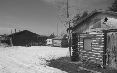
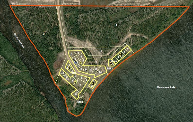
The Northern Settlement of Descharme Lake is located north of La Loche, SK on highway 969.  This community, on the northern side of Clearwater River Provincial Park.
  
Descharme Lake Basemap
File Size: 172 kb
File Type: pdf
Download File

Descharme Lake

Planning Documents

*All plans and bylaws available for download on this site may not include amendments and should not be used for legal purposes*

Community Highlights (2012): The Saskatchewan Ministry of First Nations and Metis Relations, with help of the Ministry of the Economy conducted a snapshot in 2012 of the key components of the community, including: local government, demographics, economic environment, training and education, infrastructure, housing, emergency services, recreational opportunities, and the community's distance from larger centres.  
   
Community Highlights - 2012
File Size: 185 kb
File Type: pdf
Download File


Wildfire Risk Assessment (2005): The Saskatchewan Ministry of Environment actively attempts to educate residents about the threat of fire within municipalities.  They conducted an assessment of each municipality to determine the likelihood of wildfires, and implement FireSmart principles to help reduce the chances of wildfires starting.  
  
WRA - Descharme Lake
File Size: 5641 kb
File Type: pdf
Download File


Back to Top
  • Home
  • COVID-19
  • Northern Municipal Services
    • Northern Municipal Services
    • Administration of the District (municipality) >
      • The District (municipality)
      • Public Notices in the District
      • Assessment Notice FAQ
      • District: Accounts Payable and Accounts Receivable
    • Northern Municipal Trust Account (NMTA) >
      • NMTA & Board
      • Northern Capital Grants Program
      • Northern Water and Sewer Program
      • Wildfire Mitigation Project
    • Northern Planning and Sustainability (NPS) >
      • NPS Unit
      • Planning for Growth North
  • Northern Communities & Areas
    • The Northern Saskatchewan Administration District (NSAD)
    • Towns >
      • La Ronge
      • Creighton
    • Northern Villages >
      • Air Ronge
      • Beauval
      • Buffalo Narrows
      • Cumberland House
      • Denare Beach
      • Green Lake
      • Ile-a-la Crosse
      • La Loche
      • Pelican Narrows
      • Pinehouse
      • Sandy Bay
    • Northern Hamlets >
      • Black Point
      • Cole Bay
      • Dore Lake
      • Jans Bay
      • Michel Village
      • Patuanak
      • St. George's Hill
      • Stony Rapids
      • Timber Bay
      • Turnor Lake
      • Weyakwin
    • District >
      • Settlements >
        • Bear Creek
        • Brabant
        • Camsell Portage
        • Descharme Lake
        • Garson Lake
        • Missinipe
        • Sled Lake
        • Southend
        • Stanley Mission
        • Uranium City
        • Wollaston Lake
      • Resort Subdivisions >
        • East Trout Lake
        • Jan Lake
        • Keeley Lake
        • Lac La Plonge
        • Little Amyot Lake
        • Little Bear Lake
        • Michel Point
        • Napatak
        • Ramsey Bay
        • Sturgeon Weir
        • Tower Beach
        • Tyrell Lake
        • Wadin Bay
        • Whelan Bay
      • Cluster Subdivisions >
        • Deschambault Lake Subdivision
        • Eagle Point Subdivision
        • English Bay Subdivision
        • Kinoosao Subdivision
        • Lamp Lake Subdivision
        • Lloyd Lake Subdivision
        • Nemeiben Lake Subdivision
        • Potato Lake Subdivision
        • Sturgeon Landing Subdivision
      • Development in the District
    • Lac La Ronge Planning Area >
      • Advisory Northern Planning Commission
      • Development in the Planning Area
      • Planning Bylaws & Maps
  • Toolkits & Resources
    • Legislation
    • Bylaw Guides
    • Emergency Preparedness and Community Safety
    • Governance and Administration
    • Assessment & Taxation
    • First Nations & Métis Engagement
    • Social Development and Healthy Communities
    • Land Use Planning
    • Maps & Databases
  • Contact Us