PLANNING FOR GROWTH NORTH
  • Home
  • Northern Municipal Services
    • About Northern Municipal Services
    • District Administration (municipality) >
      • About the District (municipality)
      • Assessment Notice FAQ
      • Accounts Payable and Accounts Receivable
      • Employment Opportunities
    • Public Notices in the District
    • Northern Municipal Trust Account Programs >
      • About the NMTA & Board
      • Northern Capital Grants Program
      • Northern Water and Sewer Program
      • Wildfire Mitigation Project
    • Northern Planning and Sustainability Unit >
      • About NPS Unit
      • Planning for Growth North
  • Northern Communities & Areas
    • The Northern Saskatchewan Administration District (NSAD)
    • Towns >
      • La Ronge
      • Creighton
    • Northern Villages >
      • Air Ronge
      • Beauval
      • Buffalo Narrows
      • Cumberland House
      • Denare Beach
      • Green Lake
      • Ile-a-la Crosse
      • La Loche
      • Pelican Narrows
      • Pinehouse
      • Sandy Bay
    • Northern Hamlets >
      • Black Point
      • Cole Bay
      • Dore Lake
      • Jans Bay
      • Michel Village
      • Patuanak
      • St. George's Hill
      • Stony Rapids
      • Timber Bay
      • Turnor Lake
      • Weyakwin
    • District >
      • About
      • Northern Settlements >
        • About
        • Bear Creek
        • Brabant
        • Camsell Portage
        • Descharme Lake
        • Garson Lake
        • Missinipe
        • Sled Lake
        • Southend
        • Stanley Mission
        • Uranium City
        • Wollaston Lake
      • Resort Subdivisions >
        • About
        • East Trout Lake
        • Jan Lake
        • Keeley Lake
        • Lac La Plonge
        • Little Amyot Lake
        • Little Bear Lake
        • Michel Point
        • Napatak
        • Ramsey Bay
        • Sturgeon Weir
        • Tower Beach
        • Tyrrell Lake
        • Waden Bay
        • Whelan Bay
      • Cluster Subdivisions >
        • Deschambault Lake Subdivision
        • Eagle Point Subdivision
        • English Bay Subdivision
        • Kinoosao Subdivision
        • Lamp Lake Subdivision
        • Lloyd Lake Subdivision
        • Nemeiben Lake Subdivision
        • Potato Lake Subdivision
        • Sturgeon Landing Subdivision
      • Development and Land Sales in the District
      • Public Notices in the District
    • Lac La Ronge Planning Area >
      • About
      • Development in the Planning Area
      • Planning Bylaws & Maps
      • Advisory Northern Planning Commission
  • Toolkits & Resources
    • Legislation
    • Bylaw Guides
    • Population
    • Governance and Administration
    • Waterworks Reporting
    • Assessment & Taxation
    • First Nations & Métis Engagement
    • Community Health, Safety and Wellbeing
    • Land Use Planning
    • Emergency Preparedness and Community Safety
    • Maps & Databases
  • Contact Us

FAQ - If Most of Buffalo Narrows Is In A Flood Plain, Where and How Can I Build?

Properties that are in danger of flooding are shown in blue in the Buffalo Narrows Flood Hazard Map.  If your property is located within the blue areas, it may be susceptible to flooding.

Provincial regulations requires the Village ensure developments are managed to minimize flood risk.  Managing development to minimize flood risk to life, property and infrastructure is a major objective of land use planning.  It is important the Village and landowners work together to anticipate and minimize flood impacts to protect people and property.

The 2006 Zoning Bylaw addressed flooding and hazard lands in section 3.13. The proposed 2018 Zoning Bylaw aims to ensure the Village's responsibilities are met by clarifying development and building requirements for landowners. 


If your property is within the the blue area on the map, you can build on these sites by following one of the three allowed methods:

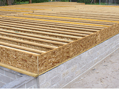
1.    Raised Floor – one option is to use a construction method that raises the floor of your building. There are few different ways to do this, with the two most popular methods shown below.​
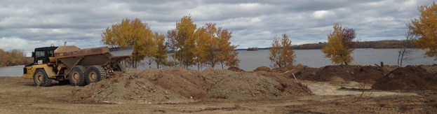
2.    Adding fill to your property – clean dirt and rocks can be brought in to raise the elevation of your property. A  plan showing how the fill will impact drainage may be required before your permit is issued to ensure there aren't problems with diverting water onto your neighbour's property. 
Picture

3.     Flood proofing your building – there are construction methods outlined in the Zoning Bylaw that protect your home from floodwaters as well. 


All of the above options may require a professional oversee the work. ​

Back to FAQs

 Northern Municipal Services:
​1-800-663-1555
​NMS@gov.sk.ca

  • Home
  • Northern Municipal Services
    • About Northern Municipal Services
    • District Administration (municipality) >
      • About the District (municipality)
      • Assessment Notice FAQ
      • Accounts Payable and Accounts Receivable
      • Employment Opportunities
    • Public Notices in the District
    • Northern Municipal Trust Account Programs >
      • About the NMTA & Board
      • Northern Capital Grants Program
      • Northern Water and Sewer Program
      • Wildfire Mitigation Project
    • Northern Planning and Sustainability Unit >
      • About NPS Unit
      • Planning for Growth North
  • Northern Communities & Areas
    • The Northern Saskatchewan Administration District (NSAD)
    • Towns >
      • La Ronge
      • Creighton
    • Northern Villages >
      • Air Ronge
      • Beauval
      • Buffalo Narrows
      • Cumberland House
      • Denare Beach
      • Green Lake
      • Ile-a-la Crosse
      • La Loche
      • Pelican Narrows
      • Pinehouse
      • Sandy Bay
    • Northern Hamlets >
      • Black Point
      • Cole Bay
      • Dore Lake
      • Jans Bay
      • Michel Village
      • Patuanak
      • St. George's Hill
      • Stony Rapids
      • Timber Bay
      • Turnor Lake
      • Weyakwin
    • District >
      • About
      • Northern Settlements >
        • About
        • Bear Creek
        • Brabant
        • Camsell Portage
        • Descharme Lake
        • Garson Lake
        • Missinipe
        • Sled Lake
        • Southend
        • Stanley Mission
        • Uranium City
        • Wollaston Lake
      • Resort Subdivisions >
        • About
        • East Trout Lake
        • Jan Lake
        • Keeley Lake
        • Lac La Plonge
        • Little Amyot Lake
        • Little Bear Lake
        • Michel Point
        • Napatak
        • Ramsey Bay
        • Sturgeon Weir
        • Tower Beach
        • Tyrrell Lake
        • Waden Bay
        • Whelan Bay
      • Cluster Subdivisions >
        • Deschambault Lake Subdivision
        • Eagle Point Subdivision
        • English Bay Subdivision
        • Kinoosao Subdivision
        • Lamp Lake Subdivision
        • Lloyd Lake Subdivision
        • Nemeiben Lake Subdivision
        • Potato Lake Subdivision
        • Sturgeon Landing Subdivision
      • Development and Land Sales in the District
      • Public Notices in the District
    • Lac La Ronge Planning Area >
      • About
      • Development in the Planning Area
      • Planning Bylaws & Maps
      • Advisory Northern Planning Commission
  • Toolkits & Resources
    • Legislation
    • Bylaw Guides
    • Population
    • Governance and Administration
    • Waterworks Reporting
    • Assessment & Taxation
    • First Nations & Métis Engagement
    • Community Health, Safety and Wellbeing
    • Land Use Planning
    • Emergency Preparedness and Community Safety
    • Maps & Databases
  • Contact Us